


PERRY 01, Wayne County, Indiana
About
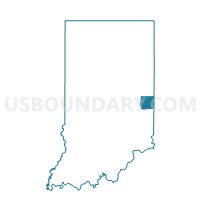
Outline

Summary
| Unique Area Identifier | 581225 |
| Name | PERRY 01 |
| County | Wayne County |
| State | Indiana |
| Area (square miles) | 17.44 |
| Land Area (square miles) | 17.43 |
| Water Area (square miles) | 0.01 |
| % of Land Area | 99.94 |
| % of Water Area | 0.06 |
| Latitude of the Internal Point | 39.97027520 |
| Longtitude of the Internal Point | -85.09685150 |
Maps


Graphs
Select a template below for downloading or customizing gragh for PERRY 01, Wayne County, Indiana


Neighbors
Neighoring Voting District (by Name) Neighboring Voting District on the Map
- CLAY 01, Wayne County, IN
- DALTON 01, Wayne County, IN
- GREENE 01, Wayne County, IN
- JEFFERSON 03, Wayne County, IN
- UNION, Randolph County, IN
Top 10 Neighboring County Subdivision (by Population) Neighboring County Subdivision on the Map
- Jefferson township, Wayne County, IN (3,482)
- Union township, Randolph County, IN (2,142)
- Green township, Wayne County, IN (1,222)
- Clay township, Wayne County, IN (1,169)
- Perry township, Wayne County, IN (835)
- Dalton township, Wayne County, IN (566)
Top 10 Neighboring Place (by Population) Neighboring Place on the Map
Top 10 Neighboring Unified School District (by Population) Neighboring Unified School District on the Map
- Nettle Creek School Corporation, IN (7,123)
- Northeastern Wayne Schools, IN (5,841)
- Union School Corporation, IN (2,959)
Top 10 Neighboring State Legislative District Lower Chamber (by Population) Neighboring State Legislative District Lower Chamber on the Map
Top 10 Neighboring State Legislative District Upper Chamber (by Population) Neighboring State Legislative District Upper Chamber on the Map
Top 10 Neighboring 111th Congressional District (by Population) Neighboring 111th Congressional District on the Map
Top 10 Neighboring Census Tract (by Population) Neighboring Census Tract on the Map
- Census Tract 103, Wayne County, IN (3,525)
- Census Tract 104, Wayne County, IN (3,482)
- Census Tract 9521, Randolph County, IN (3,023)
Top 10 Neighboring 5-Digit ZIP Code Tabulation Area (by Population) Neighboring 5-Digit ZIP Code Tabulation Area on the Map
- 47346, IN (4,082)
- 47393, IN (1,704)
- 47345, IN (1,448)
- 47354, IN (1,129)
- 47358, IN (996)
- 47339, IN (669)